Climate Change
&
The Wildlife Connectivity Institute
At the Wildlife Connectivity Institute, our mission is to help agencies and the public learn more about climate driven droughts, fires, floods, storms, and other climate changes that affect wildlife’s ability to move, and to take action to protect those movements.
Connectivity and Climate Change Resources
This Resources Page provides information and links to protecting wildlife movement in the face of the climate crisis.


Journal Article on Wildlife Crossings & Climate Change
Evaluating and Elevating the Role of Road Wildlife Crossings in Climate Adaptation
An open access journal article in Frontiers in Ecology and the Environment
DOI: 10.1002/fee.2816
Our director Dr. Cramer was a co-author on this in-depth article about how predicting where wildlife will need to move in the future in the face of climate change, and how locating wildlife crossing mitigation proactively in those areas can help wildlife move and adapt to a future that may not look the same as today.
Climate Change and Wildlife Connectivity Conference
The Pew Charitable Trusts joined federal, state, and tribal partners in hosting the Corridors, Connectivity and Crossings Conference in Tucson, Arizona, in May, 2023.
The three-day event featured scientists, practitioners, and policymakers leading technical trainings, sharing research, and discussing policy innovations based on the latest developments in wildlife migration and landscape connectivity conservation. Dr. Cramer was a featured speaker.

Climate-Informed Wildlife Crossings

Experts agree on the need for climate-informed wildlife crossings
They call for action and share recommendations for how infrastructure can help nature adapt to a changing climate now and in the future.
“Leaders and practitioners can work to identify the areas where wildlife and fish need to move that are bisected by roads, and where those movements will be critical to adapting to climate change. Our efforts to create a more resilient transportation system in the face of climate change work hand and hand with creating a more connected natural world that too can withstand future changes.”
- Dr. Patricia Cramer, director of the Wildlife Connectivity Institute
Place Wildlife Crossing Structures In Natural Features
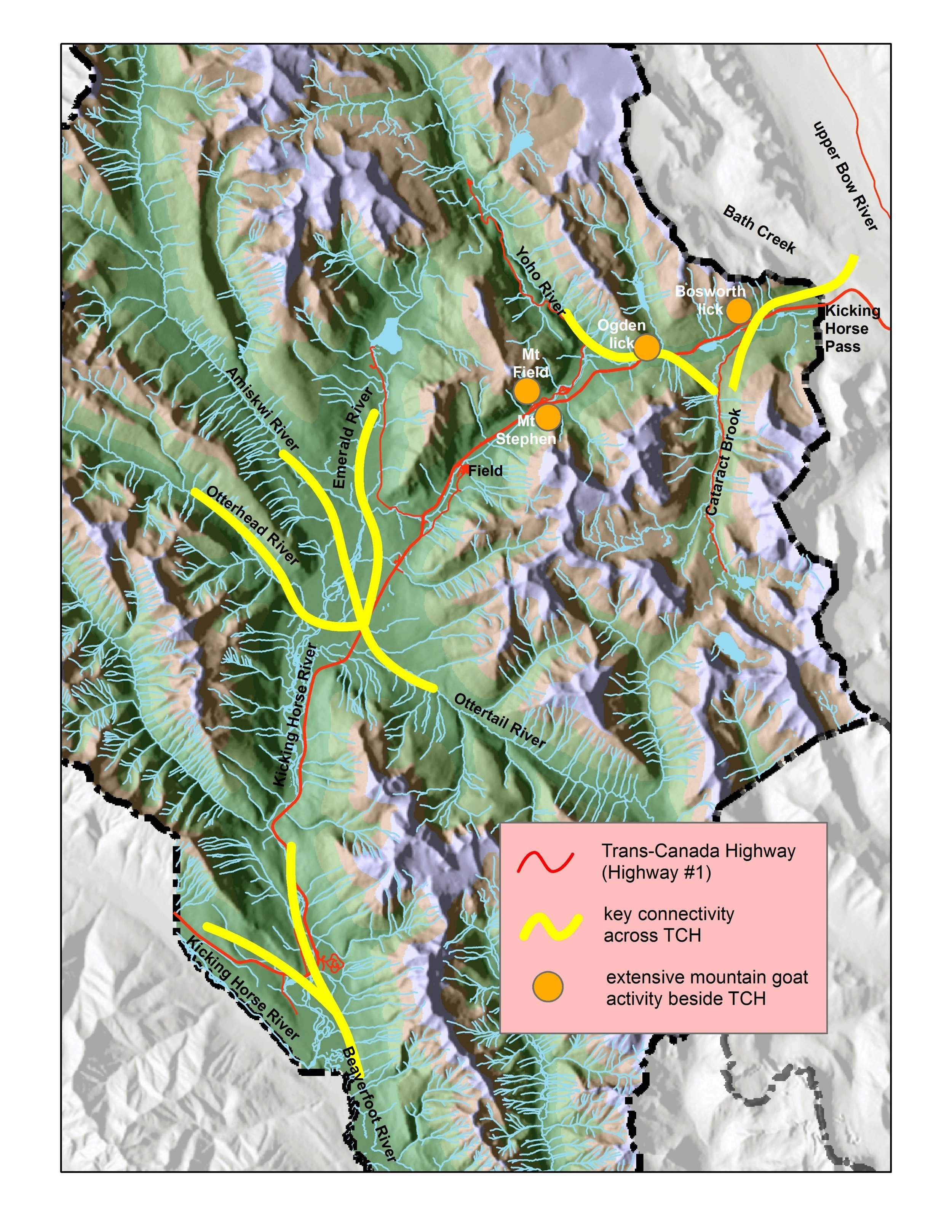
River Drainages Are Natural Features to Place Wildlife Crossing Structures
In Canada’s Yoho National Park, wildlife ecologist T. Kinley mapped where several river drainages converged across the Trans Canada Highway to locate where wildlife crossing structures would best facilitate wildlife movement north and south of the highway. Rivers and geologic features such as ridges have a high probability of surviving climate change. These lines of river systems are combined with known locations of mountain goat activity along the highway. See more in our report link below. Check out “Ecological Data” Section.

Connectivity and Climate Change Toolkit
Resources

The Voluntary Guidance for States to Incorporate Climate Adaptation into State Wildlife Actions Plans and other Management Plans aims to help state fish and wildlife agencies incorporate climate change adaptation for fish and wildlife and their habitats into State Wildlife Action Plans (SWAPs) and other natural resource management plans.
